3 Step Guide to Publishing Hard Copy Cartography in ArcGIS Pro
Like almost every other GIS professional I’ve been producing hardcopy maps using the trusty workhorse of GIS, ArcMap for quite a while now; with the occasional foray on it’s slightly more hipster cousin QGIS. Over the last couple of years ESRI have been developing their cloud GIS and a new Desktop App called ArcGIS Pro.
But it’s a major headache switching to a new platform when you’ve got work to be getting on with and there’s always the risk that the product just isn’t ready yet. Yet on the other hand you could be spending twice as long as you should if the new product is in fact better.
I gave Pro a go and I think quality map production is now better done here.
Authoring print maps with ArcGIS Pro makes quick quality cartography more manageable. Checkout my 3 step process to production.
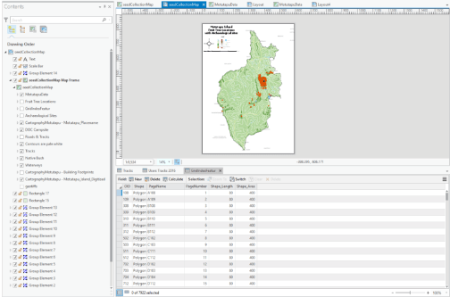
Step #1: Making Maps
Good map makers focus on content. To create something great in ArcPro you start out with a basemap, then add your content and make any changes or customization’s you need to. But you start with a map, and then add to it.

You do that by hitting the New Map icon, then you can start pulling content from all over to make a meaningful map. Adding content to ArcGIS Pro is easy following the offical guide, in this particular example I’m pulling some data out of a geodatabase, a random shapefile and some of my cloud content from ArcGIS online.

Step #2: Layout your Layers
Layouts are Pro’s design area. This is where you take your map or maps and start making them ready for the printer. You need to hit the New Layout button and you’re off to a new design. You can insert one or more maps into the layout and you can even shape those inserts with a handy Reshape design tool.
Step #3: Map Out the Marginalia
Now it’s time to add in the classic content. Legend, Scale bar, North arrow etc. With the move to a layout format ESRI have taken on a more graphical design mentality. As such you can think of this stage of design as if you were working in Illustrator or Photoshop. It has a definite move towards the concepts of Avensia and other software packages with such a heavy focus on the Cartographic principles, rather than the only concentrating on the GIS components.
Transitioning to arcPro for map design and production may be easier than you imagined. Spend 5 minutes making maps and you might be surprised what you can achieve these days.
If you enjoyed this post, I’d be very grateful if you’d help spread it by emailing it to a friend, or sharing it on Twitter or Facebook using the icons below. We’re also working on a monthly newsletter if you fancy signing up. Thank you!

Leave a comment